news, latest-news, flooding, namadgi national park, naas bridge, bridge collapse, namadgi bridge collapse, canberra flooding, queanbeyan, ses
ACT SES crews have responded to more than 150 calls for help amid a deluge of rain which caused a bridge in Namadgi National Park to be washed away by floodwater. ACT SES chief officer Anthony Draheim said crews had responded to 167 calls for assistance since midnight and 87 jobs were outstanding as of noon. Eight crews were assisting with the calls for leaking roofs, fallen trees and flooded roads. Mr Draheim also warned for people to avoid rivers and stormwater drains due to the rising water levels. Multiple crossings have been closed to drivers due to the flooding, including Uriarra Crossing, Coppins Crossing, Angle Crossing, Point Hut Crossing, Oaks Estate Croissing, Sunshine Crossing and Paddys River Road. Dudley Street in Yarralumla has been closed in both directions between Novar and Kent streets. Cotter Road has also been closed in Yarralumla and is expected to be in place for at least the next 24 to 48 hours. The Naas Bridge, which crosses the Gudgenby River, was swept away by the floods about 7am on Tuesday. The road is one of the major crossings in Namadgi, and was undergoing construction work to widen the bridge to two lanes. Emergency crews were on the scene, as of 11.30am. It comes as water has been spilling out of major dams across Canberra and the surrounding region, causing many roads to be cut off, due to the sheer amount of rain falling. National parks and nature reserves have also been closed to the public due to flooding and high winds forecast. Namadgi National Park south of Tharwa has been closed, including the visitor centre, along with Tidbinbilla Nature Reserve, Googong Dam and Googong Foreshore, all swimming areas along the Murrumbidgee River corridor, Caves Crossing and Murrays Corner Crossing on Paddys River and Molonglo River Reserve. ACT flora and fauna conservator Ian Walker said they had been closed to protect people. “We are advising all Canberrans to avoid these areas as we see heavy rain and extreme weather continue over the coming days,” Mr Walker said. “Flood waters can occur suddenly and without much warning, leaving you trapped or stranded if you are unprepared.” Mr Walker said there could be more closures, and warned people to also be wary around trees and other debris in parks and reserves in coming days. “Strong winds are dangerous and will move fallen trees unpredictably and can even topple or uproot standing trees.” Up to 90 millimetres is expected to fall in Canberra on Tuesday, on top of the more than 50 millimetres that was recorded in the 24 hours since 9am on Monday. Spectacular images have emerged of Googong Dam spilling large amounts of water into the Queanbeyan River, while Scrivener Dam also released water late on Monday night, as Canberra’s dams reached 100 per cent capacity earlier that day. READ MORE: Shannons Flat resident Sonja Valenta said the Naas Bridge had been undergoing significant construction. She alerted authorities of the collapse to the bridge just after 7.30am on Tuesday. “A lot of the concrete bollards that were holding up the bridge have been washed away and sections of the road as well,” she said. Cars were able to cross the bridge on Monday night, but floodwaters were seen rising close to the road level at the time, Ms Valenta said. The collapse has meant residents in the area would need to detour to Cooma in order to access Canberra, rather than cutting straight through the national park. Forecaster at the Bureau of Meteorology Helen Reid said the heaviest of the falls were expected in the early afternoon, but Canberra would get consistent rainfall for most of Tuesday. The rain had started to ease in Canberra by 5pm. “It’s such a broad system that we’re seeing consistent totals across lots of areas,” she said. “The next few hours will be the telling ones. “It will ease off on Wednesday and the day won’t be as wet.” Meanwhile, major roads around Queanbeyan have been shut off due to flooding. A minor flood warning was issued with the Queanbeyan River expected to hit 6.3 metres about midnight. The rising water resulted in the Morisset Street bridge to be closed off to motorists. Travellers staying at the nearby caravan park were told to evacuate at about 2pm. Guests were relocated to the Queanbeyan Showground and Crestview Tourist Park. However, SES Queanbeyan unit operations officer Brent Hunter said properties and businesses were not expected to be inundated. “There’s been an obvious rise in the river heights around Queanbeyan and we have seen a few road closures,” he said. “However, we’re still not expecting an inundation of properties, but is a dynamic situation. “The biggest area of concern for us on Tuesday is the Queanbeyan CBD.” The ACT has supplied seven crews to flood-affected areas in Sydney and additional crews are on standby to be deployed. IN OTHER NEWS: Our journalists work hard to provide local, up-to-date news to the community. This is how you can continue to access our trusted content:
/images/transform/v1/crop/frm/Yb2Jn5LgcGxmVnDUUjd5xi/3a26ae3f-078e-44d4-a464-107b221280d5.jpg/r10_376_4022_2643_w1200_h678_fmax.jpg
ACT SES crews have responded to more than 150 calls for help amid a deluge of rain which caused a bridge in Namadgi National Park to be washed away by floodwater.
ACT SES chief officer Anthony Draheim said crews had responded to 167 calls for assistance since midnight and 87 jobs were outstanding as of noon.

Eight crews were assisting with the calls for leaking roofs, fallen trees and flooded roads.
Mr Draheim also warned for people to avoid rivers and stormwater drains due to the rising water levels.
Multiple crossings have been closed to drivers due to the flooding, including Uriarra Crossing, Coppins Crossing, Angle Crossing, Point Hut Crossing, Oaks Estate Croissing, Sunshine Crossing and Paddys River Road.
Dudley Street in Yarralumla has been closed in both directions between Novar and Kent streets. Cotter Road has also been closed in Yarralumla and is expected to be in place for at least the next 24 to 48 hours.
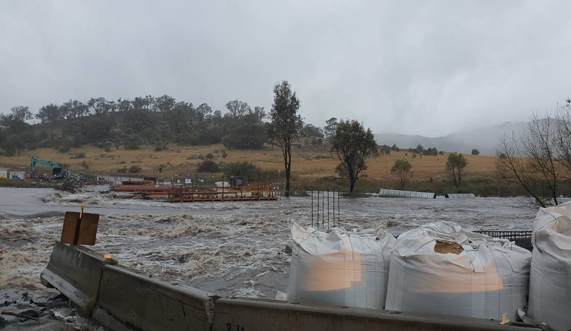
The Naas Bridge, which crosses the Gudgenby River, was swept away by the floods about 7am on Tuesday.
The road is one of the major crossings in Namadgi, and was undergoing construction work to widen the bridge to two lanes. Emergency crews were on the scene, as of 11.30am.
It comes as water has been spilling out of major dams across Canberra and the surrounding region, causing many roads to be cut off, due to the sheer amount of rain falling.
National parks and nature reserves have also been closed to the public due to flooding and high winds forecast.
Namadgi National Park south of Tharwa has been closed, including the visitor centre, along with Tidbinbilla Nature Reserve, Googong Dam and Googong Foreshore, all swimming areas along the Murrumbidgee River corridor, Caves Crossing and Murrays Corner Crossing on Paddys River and Molonglo River Reserve.
ACT flora and fauna conservator Ian Walker said they had been closed to protect people.
“We are advising all Canberrans to avoid these areas as we see heavy rain and extreme weather continue over the coming days,” Mr Walker said.

Googong Dam reaches 100 per cent capacity and overflows due to heavy rainfall. Picture: Dion Georgopoulos
“Flood waters can occur suddenly and without much warning, leaving you trapped or stranded if you are unprepared.”
Mr Walker said there could be more closures, and warned people to also be wary around trees and other debris in parks and reserves in coming days.
“Strong winds are dangerous and will move fallen trees unpredictably and can even topple or uproot standing trees.”
Spectacular images have emerged of Googong Dam spilling large amounts of water into the Queanbeyan River, while Scrivener Dam also released water late on Monday night, as Canberra’s dams reached 100 per cent capacity earlier that day.
Shannons Flat resident Sonja Valenta said the Naas Bridge had been undergoing significant construction.
She alerted authorities of the collapse to the bridge just after 7.30am on Tuesday.
“A lot of the concrete bollards that were holding up the bridge have been washed away and sections of the road as well,” she said.
Cars were able to cross the bridge on Monday night, but floodwaters were seen rising close to the road level at the time, Ms Valenta said.

The bridge was undergoing construction to widen it to two lanes. Picture: Sonja Valenta
The collapse has meant residents in the area would need to detour to Cooma in order to access Canberra, rather than cutting straight through the national park.
Forecaster at the Bureau of Meteorology Helen Reid said the heaviest of the falls were expected in the early afternoon, but Canberra would get consistent rainfall for most of Tuesday.
The rain had started to ease in Canberra by 5pm.
“It’s such a broad system that we’re seeing consistent totals across lots of areas,” she said.
“The next few hours will be the telling ones.
“It will ease off on Wednesday and the day won’t be as wet.”
Meanwhile, major roads around Queanbeyan have been shut off due to flooding.
A minor flood warning was issued with the Queanbeyan River expected to hit 6.3 metres about midnight.
The rising water resulted in the Morisset Street bridge to be closed off to motorists.
Travellers staying at the nearby caravan park were told to evacuate at about 2pm. Guests were relocated to the Queanbeyan Showground and Crestview Tourist Park.
However, SES Queanbeyan unit operations officer Brent Hunter said properties and businesses were not expected to be inundated.
“There’s been an obvious rise in the river heights around Queanbeyan and we have seen a few road closures,” he said.
“However, we’re still not expecting an inundation of properties, but is a dynamic situation.
“The biggest area of concern for us on Tuesday is the Queanbeyan CBD.”
The ACT has supplied seven crews to flood-affected areas in Sydney and additional crews are on standby to be deployed.
Our journalists work hard to provide local, up-to-date news to the community. This is how you can continue to access our trusted content: