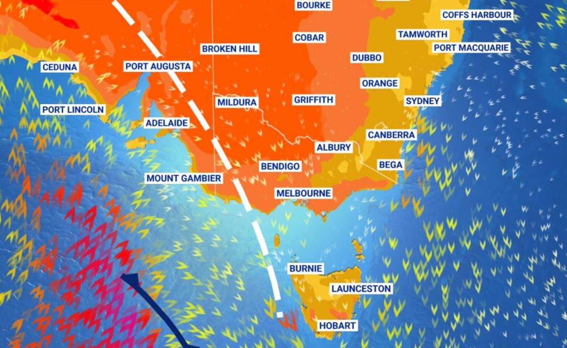
It hasn’t been this hot since January last year with some areas expected to surpass 40C in the coming days. But enjoy it while you can.
Both Melbourne and Hobart are set to swelter through their most blistering conditions for almost a year today with the mercury set to top out at around 38C. Adelaide has already experienced its hottest morning since last summer.
The whole of Victoria and much of South Australia, Tasmania and southern New South Wales are in the grip of a low intensity heatwave as Australia’s “heat engine” in northern Western Australia cranks into life after a slumber in December. Perth also continues to swelter as the summer weather bites.
Thankfully, unlike last year, we aren’t in the middle of a horror brushfire season. Nonetheless there are multiple fire weather warnings in place. The Mallee, Wimmera and Northern Country forecast areas of Victoria are under threat, as is a large chunk of SA including the Eyre and York peninsulas and Kangaroo Island in SA and the Midlands, Upper Derwent Valley and south eastern areas of Tasmania.
But the searing heat won’t last. It’s already got its marching orders.
“A cool change will reach Adelaide at about 3 or 4pm today, arriving in Melbourne and Hobart overnight,” said Sky News Weather meteorologist Rob Sharpe.
“But it will be a dry change with just the odd shower and it will be quite weak dragging the heat into southern NSW where it will remain for Tuesday and Wednesday,” he said.
RELATED: 2020 Australia’s fourth warmest year since records began
The arrival of the La Nina climate driver has led to a relatively mild December with extra moisture aided by the monsoon. However, the monsoon is currently in an inactive phase and that’s left room for some dry heat from Central Australia to work its way down toward the south and east.
But the rain is never far away this summer and over the coming week, says Mr Sharpe, with downpours likely especially for the east coast.
Melbourne’s high of 38C today will fall off a cliff on Tuesday when it will see a maximum of just 24C. It’s a bit of a seesaw though with a hot Wednesday in the mid-thirties before a stronger cool change arrives on Thursday and that will anchor temperatures for several days to around the 20C mark.
The last day it surpassed 38C in Melbourne was on January 31, 2020, when the heat maxxed out at 42.9C.
“Albury-Wodonga is in the midst of a severe heatwave with temperatures in the mid-to-high thirties and low forties from Monday to Wednesday,” Mr Sharpe told news.com.au.
“It is one of few towns where the current heatwave is on par with the kind of heat that came through in the record-breaking November heatwave.”
RELATED: UN calls out Aussie suburb for dire heat record
Similar conditions in Adelaide today but the drop off when the change comes through won’t be as steep. Tuesday is set for a maximum of 32C and then each day for the rest of the week will steadily get less hot with highs of just 23C on the weekend.
Toasty in Tassie with Hobart on 36C today and then a huge 15 degree drop to a mere 21C on Tuesday and some possible shows. Like Melbourne, there will be a bump up, to a maximum of 27C on Wednesday, and then settling in for a run of around 20C days heading into the weekend.
A warm week in Canberra which will see some of that heat from Victoria and South Australia passing through. A high of 33C on Monday climbing to 36C by Wednesday – that would be the capital’s hottest day since last January.
Then the mercury will drift down to the low-thirties and into the mid-twenties by the weekend.
Sydney will one of the cooler capitals this week – it might not even make it to 30C. But it will get close, touching around 29C every day until Thursday when it should do a small step change into the mid-twenties.
Wetter in the state’s south with showers possible for costal towns later in the week.
Tropical Queensland has been absolutely drenched but the clouds are clearing. Up to 20mm could fall on Townsville tomorrow but by Thursday it should be dry and remain that way for the next few days.
Brisbane, which hasn’t seen the rain experienced further north, will stay essentially dry with the odd sprinkle here and there possible.
Temperatures will bounce around the high-twenties and low-thirties until the end of the week but could rise for the weekend.
The monsoon might be in an inactive phase but that doesn’t mean no rain at all. Darwin will still be hot, muggy and wet this week. Highs of around 33C, overnight lows of 26C and possible storms.
Perth’s run of hot days continues unabated. It will be north of 30C every day this week in the WA capital. The only saving grace is it will be in the low- to mid-thirties, not pushing 40C as it has in recent weeks.


