news, latest-news, NSW Flood, ACT, Canberra, Weather, Canberra weather
The Bureau of Meteorology has added the ACT and region to a severe weather warning. The warning is for damaging winds, heavy rainfall, abnormally high tides and damaging surf, and encompasses most of NSW. While Canberra has so far escaped the huge rainfall hitting further north in NSW, a big dump of rain is on its way. “Heavy rainfall will … extend to areas of the ACT, South Coast, Snowy Mountains and Northern Tablelands during Tuesday. There is an enhanced risk with any thunderstorm activity,” the bureau said in the warning. The bureau warns of very heavy surf south of Moruya, and the risk of localised damage and coastal erosion. Abnormally high tides could also cause sea water flooding on Tuesday morning. The bureau has also issued a “minor flood watch” for Queanbeyan for Tuesday. Eight flood evacuation orders have been issued for the NSW mid-north coast as wild weather and torrential rain continues to lash much of the state’s east. The Bureau of Meteorology predicts the ACT could receive up to 70mm of rain on Tuesday. The bureau expects Canberra to receive 15-20mm of rain on Monday. Nambucca Heads, by comparison, recorded 245mm of rain in the 24 hours to 9am Monday and Coffs Harbour received 183mm. Heavy rain is likely to lead to flash flooding and will remain a serious risk for the Northern Rivers and Mid-North Coast on Monday and Tuesday, the bureau warned. Risks remain for the Hunter and Central Tablelands districts, particularly as catchments are already saturated. The ACT has avoided the brunt of the rain and flooding affecting large areas of NSW so far. Just 5mm of rain fell in Canberra in the 24 hours between 9am Sunday and 8am Monday, and about 11mm in the preceeding 24 hours. Meanwhile at Ulladulla, Nowra and Jervis Bay, at least 18, 37.6 and 15.8 millimetres of rain fell during the same 24 hours. According to Icon Water, ACT and Queanbeyan dams are completely full for just the second time since the enlarged Cotter Dam was completed in 2013. Corin and Cotter dams were at capacity on Monday morning, and by the afternoon so, too, were Bendora and Googong dams. Combined, they hold 277.83GL. They had dropped to below 45 per cent – or 123.6GL – in February last year. Despite Canberra’s less severe conditions events such as the Big Canberra Bike Ride were forced to cancel. READ MORE: Drier conditions are predicted from midweek. Wednesday is expected to be cloudy with a potential shower with a top of 22 degrees. Sunnier conditions are forecast for Thursday and Friday; both days are expected to be partly cloudy. There is a slight chance of rain on Thursday, which is forecast to reach a slightly warmer 23 degrees. The weekend will likely begin with a grey start. Saturday is predicted to be cloudy while Sunday expected to be partly cloudy, with maximum temperatures for both days forecast to reach 22 degrees. The State Emergency Service advises that people should: Our journalists work hard to provide local, up-to-date news to the community. This is how you can continue to access our trusted content:
/images/transform/v1/crop/frm/3BUUzmFAhrhLyX9rFCubPq5/db71f1bf-97a0-4ade-b067-b58844de8014.png/r0_177_700_573_w1200_h678_fmax.jpg
The Bureau of Meteorology has added the ACT and region to a severe weather warning.
The warning is for damaging winds, heavy rainfall, abnormally high tides and damaging surf, and encompasses most of NSW.

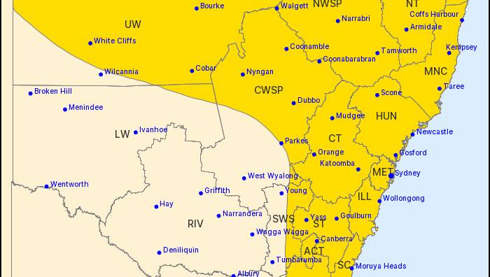
The bureau’s weather warning, issued at noon on Monday.
While Canberra has so far escaped the huge rainfall hitting further north in NSW, a big dump of rain is on its way.
“Heavy rainfall will … extend to areas of the ACT, South Coast, Snowy Mountains and Northern Tablelands during Tuesday. There is an enhanced risk with any thunderstorm activity,” the bureau said in the warning.
The bureau warns of very heavy surf south of Moruya, and the risk of localised damage and coastal erosion. Abnormally high tides could also cause sea water flooding on Tuesday morning.
The bureau has also issued a “minor flood watch” for Queanbeyan for Tuesday.
Eight flood evacuation orders have been issued for the NSW mid-north coast as wild weather and torrential rain continues to lash much of the state’s east.
The Bureau of Meteorology predicts the ACT could receive up to 70mm of rain on Tuesday. The bureau expects Canberra to receive 15-20mm of rain on Monday.
Nambucca Heads, by comparison, recorded 245mm of rain in the 24 hours to 9am Monday and Coffs Harbour received 183mm.
Heavy rain is likely to lead to flash flooding and will remain a serious risk for the Northern Rivers and Mid-North Coast on Monday and Tuesday, the bureau warned.
Risks remain for the Hunter and Central Tablelands districts, particularly as catchments are already saturated.
The ACT has avoided the brunt of the rain and flooding affecting large areas of NSW so far.
Just 5mm of rain fell in Canberra in the 24 hours between 9am Sunday and 8am Monday, and about 11mm in the preceeding 24 hours.
According to Icon Water, ACT and Queanbeyan dams are completely full for just the second time since the enlarged Cotter Dam was completed in 2013.
Corin and Cotter dams were at capacity on Monday morning, and by the afternoon so, too, were Bendora and Googong dams. Combined, they hold 277.83GL.
They had dropped to below 45 per cent – or 123.6GL – in February last year.
Despite Canberra’s less severe conditions events such as the Big Canberra Bike Ride were forced to cancel.
Drier conditions are predicted from midweek. Wednesday is expected to be cloudy with a potential shower with a top of 22 degrees.
Sunnier conditions are forecast for Thursday and Friday; both days are expected to be partly cloudy.
There is a slight chance of rain on Thursday, which is forecast to reach a slightly warmer 23 degrees.
The weekend will likely begin with a grey start. Saturday is predicted to be cloudy while Sunday expected to be partly cloudy, with maximum temperatures for both days forecast to reach 22 degrees.
The State Emergency Service advises that people should:
- Move vehicles under cover or away from trees.
- Secure or put away loose items around your house, yard and balcony.
- Keep at least 8 metres away from fallen power lines or objects that may be energised, such as fences.
- Trees that have been damaged by fire are likely to be more unstable and more likely to fall.
- Report fallen power lines to either Ausgrid (131 388), Endeavour Energy (131 003), Essential Energy (132 080) or Evoenergy (131 093) as shown on your power bill.
- Don’t drive, ride or walk through flood water.
- Keep clear of creeks and storm drains.
- If you are trapped by flash flooding, seek refuge in the highest available place and ring 000 if you need rescue.
- Be aware that run-off from rainfall in fire affected areas may behave differently and be more rapid. It may also contain debris such as ash, soil, trees and rocks.
- After bushfires, heavy rain and the loss of foliage can make the ground soft and heavy, leading to a greater chance of landslides.
- Stay vigilant and monitor conditions. Note that the landscape may have changed following bushfires.
- For emergency help in floods and storms, ring your local SES Unit on 132 500.
Our journalists work hard to provide local, up-to-date news to the community. This is how you can continue to access our trusted content:

Canberra was hit with rain over the weekend. Picture: Sitthixay Ditthavong